France has officially announced the end of its use of the Mercator projection in all diplomatic contexts. This major policy change follows France’s active co-sponsorship and supportive vote for a historic United Nations General Assembly resolution entitled “Correct the Map,” which was originally introduced by the African Group.
Inherited from the 16th century, the standard Mercator projection was originally designed specifically for maritime navigation because its mathematical properties allow a route with a constant bearing to appear as a straight line.
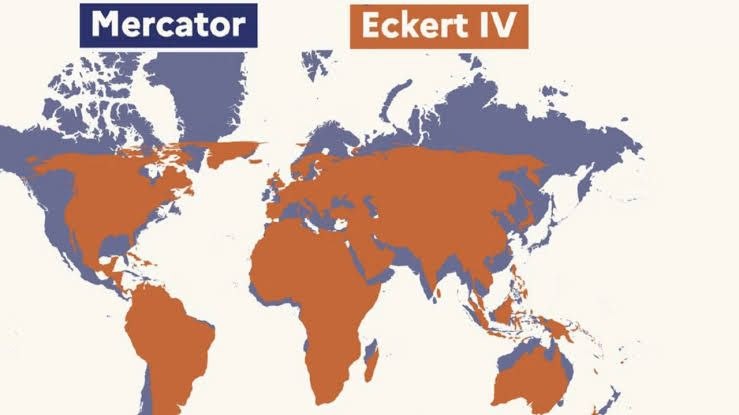
However, institutional cartography’s reliance on this model has long perpetuated a severe visual bias. The projection distorts the relative sizes of global landmasses, vastly enlarging regions near the poles—such as North America and Europe—while drastically shrinking territories closest to the Equator.
Although the 16th-century model was never designed to express a politicized viewpoint, its widespread institutional use has unconsciously shaped global perceptions. By making Africa look artificially smaller, its continued use has helped entrench and perpetuate the narrative that the continent occupies a diminished place on the international stage.
Recognizing that maps are never neutral and carry profound cognitive, educational, economic, and political implications, the African Group spearheaded the “Correct the Map” initiative at the UN. The newly adopted resolution acknowledges that traditional map representations constitute a historical bias that distorts continental proportions to the detriment of equatorial regions.
The resolution encourages UN Member States to transition toward fairer map representations in official documents and school textbooks, invites relevant UN agencies to develop guidelines on good cartographic practice, and requests a comprehensive implementation report from the Secretary-General by the eighty-third session.
According to documents reaching Capital, on September 4, 2026, France joined the initiative by co-sponsoring and voting in favor of the text. This move positions France as a leading European nation to address global cartographic bias, echoing the African Union’s “Correct the Map” campaign.
Officials emphasize that this powerful symbolic gesture builds directly upon commitments forged at the Africa Forward Summit in Nairobi in May 2026, fostering a more equal and balanced partnership between African countries and France.
In alignment with the UN adoption, the French Ministry for Europe and Foreign Affairs is formally phasing out the Mercator projection from its diplomatic operations. This policy builds upon a trajectory begun in 2021, during which France steadily removed the projection from its public websites and educated the public on map biases during major events like the Saint-Dié-des-Vosges International Geography Festival.